
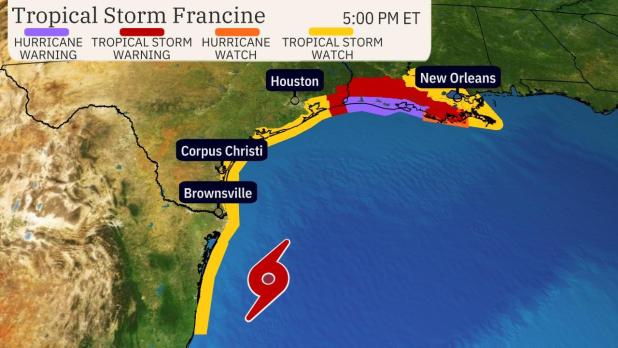
The storm is predicted to make landfall in the purple area on the map, as of Monday at 5 p.m.
Tropical storm now expected to hit on west end of Vermilion Parish, Wednesday afternoon
As Tropical Storm Francine approaches Louisiana, the forecast for Vermilion Parish is getting more severe. Francine is expected to bring 100 mph winds and a potential 12-foot storm surge to the parish’s coastline.
On Monday morning, Francine was predicted to make landfall in Intracoastal City late Wednesday night. It was forecasted to be a Cat. 1 (75 miles per hour winds) hurricane.
Five hours later, the news did not get any better for Vermilion Parish.
The National Hurricane Center has shifted the landfall prediction to the west but has also changed the hurricane’s strength by landfall.
As of 5 p.m. on Monday, the hurricane center said Francine is expected to make landfall near the Cameron and Vermilion parish lines (west of Pecan Island) at around 1 o’clock on Wednesday afternoon. The parish is expected to begin feeling 40-mile-per-hour winds Tuesday night.
However, because the tropical storm’s wind speeds as of 5 p.m. on Monday were 65 miles per hour, the hurricane center predicts Francine could have 100-mile-per-hour winds (Cat. 2) by the time it makes landfall.
Vermilion Parish Office of Emergency Preparedness Director Homer Stelly advises everyone in the parish to begin planning for a strong, wet hurricane.
Because the storm has increased its speed, the total rainfall in the parish will be around six to eight inches.
However, if it makes landfall near or in Vermilion Parish, the parish could feel winds anywhere from 70 to 90 miles per hour.
As of 5 p.m. on Monday, there is only a volunteer evacuation in the parish.
Expect parts of the parish to lose electricity because of fallen branches from the high winds.
Many who live in the parish’s low-line area are worried about the size of the storm surges the National Hurricane Center is forecasting.
Based on the noon readings on Monday, from Cameron Parish to Port Fourchon (below New Orleans), the National Hurricane Center expects the parishes along the coast to receive a five-foot to a 10-foot storm surge.
Those storm surge numbers were based on whether Francine made landfall in Intracoastal City.
Parish officials held two Office of Emergency Preparedness meetings on Monday in the courthouse.
All the mayors, some police chiefs, Sheriff Eddie Langlnais, along with other parish officials attended the meetings.
Police Juror Errol Domingue, a sugar cane farmer living south of Erath, is concerned that the hurricane making landfall west of the parish bodes wrose news for storm surge predictions.
At the meeting, Domingue asked Doug Crammer of NOAA if the storm surge could be higher than 10 feet if landfall is more west.
“It may be higher by as much as two feet,” said Crammer.
If Francine makes landfall on the west end of Vermilion Parish, residents living south of Erath, Delcambre, and in the Henry, Pecan Island, and the Forked area could expect a 10-foot to 12-foot storm surge along the coastline. This means they may expect the storm surge water to reach their area. However, the storm surge would not begin to reach the coastline until a few hours after the storm left Vermilion Parish.
Domingue, a sugar cane farmer, attended the OEP meeting. Those in the Police Jury meeting room turned to Domingue to see what kind of water damage residents should expect from a 10-foot storm surge and a five-storm surge.
Domingue stated that a 10-foot storm surge would likely cause flooding in the Henry Plant area, south of Delcambre, all of Pecan Island, and the Intracoastal City area.
If the storm moves east, the parish could receive a five-foot surge, meaning water would travel south of La. 330, south of Henry, near Boston.
Pecan Island and Intracoastal City could still receive water from the surge.
However, if Francine packs 100 miles per hour winds and lands on the west end of the parish, there is a chance the parish could see a 12-foot storm surge.
Hurricane Rita (2005) brought a 12-foot storm surge, which flooded most of Erath, Delcambre, Intracoastal City, and Pecan Island and stopped in Esther.
Three years later, when Hurricane Ike landed in 2008, the parish experienced a 10-foot storm surge. It flooded Erath, Intracoastal City, Delcambre, and the Pecan Island area.
“It is not good,” said Domingue. “We need her to make landfall on the state’s east side, not on the west side.”