RSS Feed

Article Image Alt Text

Pecan Island Water Works District No. 3

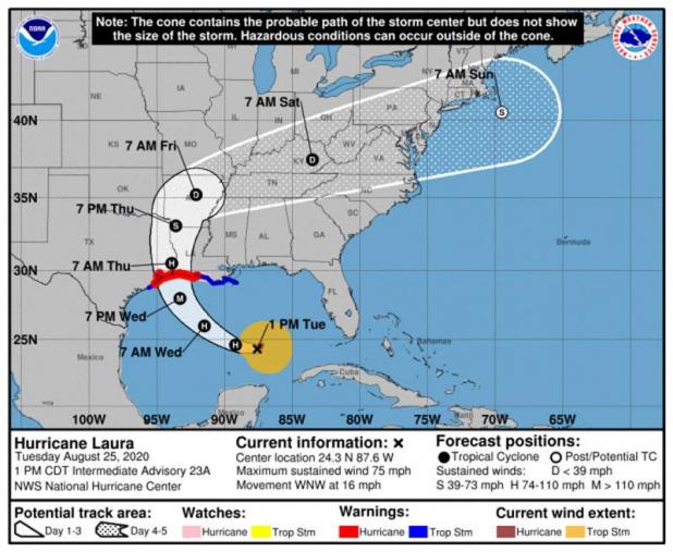
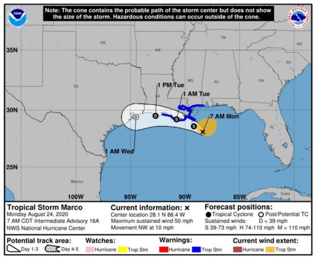
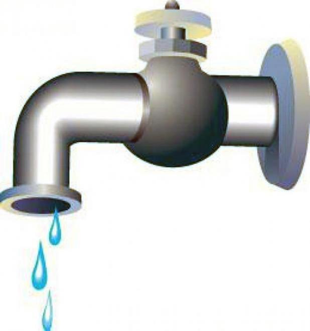
The Pecan Island Water Works District No. 3 will be turning the water off plant either late Tuesday or early Wednesday.
The district will be turning the water off at the water plant due to the potential threat from Hurricane Laura. The plant suffered damage during Hurricane Rita in 2005. The water had been left on and a busted pipe led to a burnt motor at the plant.
Those who are on the water system are asked to please make preparations to be without water for a couple of days.

Article Image Alt Text

1 P.M. UPDATE.: LAURA NOW A HURRICANE, BUILDING TOWARD CATEGORY 3 STRENGTH

NATIONAL HURRICANE CENTER
HURRICANE LAURA
Hurricane Laura Intermediate Advisory Number 23A
NWS National Hurricane Center Miami FL AL132020
100 PM CDT Tue Aug 25 2020
...LAURA MOVING WEST-NORTHWESTWARD ACROSS THE SOUTHEASTERN GULF OF
MEXICO...
...EXPECTED TO STRENGTHEN INTO A MAJOR HURRICANE BY WEDNESDAY
NIGHT...
SUMMARY OF 100 PM CDT...1800 UTC...INFORMATION
----------------------------------------------
LOCATION...24.3N 87.6W
ABOUT 525 MI...845 KM SE OF LAKE CHARLES LOUISIANA
ABOUT 560 MI...900 KM SE OF GALVESTON TEXAS
MAXIMUM SUSTAINED WINDS...75 MPH...120 KM/H
PRESENT MOVEMENT...WNW OR 295 DEGREES AT 16 MPH...26 KM/H
MINIMUM CENTRAL PRESSURE...990 MB...29.24 INCHES
WATCHES AND WARNINGS
--------------------
CHANGES WITH THIS ADVISORY:
None.
SUMMARY OF WATCHES AND WARNINGS IN EFFECT:
A Storm Surge Warning is in effect for...
* San Luis Pass Texas to the Mouth of the Mississippi River
A Hurricane Warning is in effect for...
* San Luis Pass Texas to Intracoastal City Louisiana
A Tropical Storm Warning is in effect for...
* Sargent Texas to San Luis Pass
* East of Intracoastal City Louisiana to the Mouth of the
Mississippi River
A Storm Surge Watch is in effect for...
* Freeport Texas to San Luis Pass
* Mouth of the Mississippi River to Ocean Springs Mississippi
* Lake Pontchartrain, Lake Maurepas, and Lake Borgne
A Hurricane Watch is in effect for...
* East of Intracoastal City to west of Morgan City Louisiana
A Storm Surge Warning means there is a danger of life-threatening
inundation, from rising water moving inland from the coastline,
during the next 36 hours in the indicated locations. For a
depiction of areas at risk, please see the National Weather
Service Storm Surge Watch/Warning Graphic, available at
hurricanes.gov. This is a life-threatening situation. Persons
located within these areas should take all necessary actions to
protect life and property from rising water and the potential for
other dangerous conditions. Promptly follow evacuation and other
instructions from local officials.
A Hurricane Warning means that hurricane conditions are expected
somewhere within the warning area. A warning is typically issued
36 hours before the anticipated first occurrence of
tropical-storm-force winds, conditions that make outside
preparations difficult or dangerous. Preparations to protect life
and property should be rushed to completion.
A Storm Surge Watch means there is a possibility of life-
threatening inundation, from rising water moving inland from the
coastline, in the indicated locations during the next 48 hours.
A Hurricane Watch means that hurricane conditions are possible
within the watch area. A watch is typically issued 48 hours
before the anticipated first occurrence of tropical-storm-force
winds, conditions that make outside preparations difficult or
dangerous.
A Tropical Storm Warning means that tropical storm conditions are
expected somewhere within the warning area.
For storm information specific to your area in the United
States, including possible inland watches and warnings, please
monitor products issued by your local National Weather Service
forecast office. For storm information specific to your area
outside of the United States, please monitor products issued by
your national meteorological service.
DISCUSSION AND OUTLOOK
----------------------
At 100 PM CDT (1800 UTC), the center of Hurricane Laura was located
near latitude 24.3 North, longitude 87.6 West. Laura is moving
toward the west-northwest near 16 mph (26 km/h), and this general
motion should continue today. A turn toward the northwest is
forecast by Wednesday, and a northwestward to north-northwestward
motion should continue through Wednesday night. On the forecast
track, the center of Laura will move across the southeastern Gulf of
Mexico today. Laura is then forecast to move over the central and
northwestern Gulf of Mexico tonight and Wednesday, approach the
Upper Texas and Southwest Louisiana coasts on Wednesday night and
move inland near those area on Thursday.
Maximum sustained winds are near 75 mph (120 km/h) with higher
gusts. Significant strengthening is forecast during the next 36
hours, and Laura is expected to be a major hurricane at landfall.
Hurricane-force winds extend outward up to 45 miles (75 km) from
the center and tropical-storm-force winds extend outward up to 175
miles (280 km).
The estimated minimum central pressure is 990 mb (29.24 inches).
HAZARDS AFFECTING LAND
----------------------
Key messages for Laura can be found in the Tropical Cyclone
Discussion under AWIPS header MIATCDAT3 and WMO header WTNT43 KNHC.
STORM SURGE: The combination of a dangerous storm surge and the
tide will cause normally dry areas near the coast to be flooded by
rising waters moving inland from the shoreline. The water could
reach the following heights above ground somewhere in the indicated
areas if the peak surge occurs at the time of high tide...
Sea Rim State Park TX to Intracoastal City LA including Sabine Lake
and Calcasieu Lake...9-13 ft
Intracoastal City to Morgan City including Vermilion Bay...7-11 ft
Port Bolivar TX to Sea Rim State Park...6-9 ft
Morgan City LA to Mouth of the Mississippi River...4-6 ft
San Luis Pass TX to Port Bolivar...3-5 ft
Galveston Bay...3-5 ft
Freeport TX to San Luis Pass...2-4 ft
Mouth of the Mississippi River to Ocean Springs MS including Lake
Borgne...3-5 ft
Lake Pontchartrain and Lake Maurepas...2-4 ft
The deepest water will occur along the immediate coast near and to
the right of the landfall location, where the surge will be
accompanied by large and destructive waves. Surge-related
flooding depends on the relative timing of the surge and the tidal
cycle, and can vary greatly over short distances. For information
specific to your area, please see products issued by your local
National Weather Service forecast office.
RAINFALL: Laura is expected to produce the following storm total
rainfall accumulations:
Western Cuba...Additional totals of 1 inch or less.
United States...From Wednesday night into Saturday, Laura is
expected to produce rainfall of 4 to 8 inches, with isolated maximum
amounts of 12 inches across portions of the west-central U.S. Gulf
Coast from western Louisiana into east Texas, and northward into
portions of the lower to middle Mississippi Valley, lower Ohio
Valley, and Tennessee Valley. This rainfall will cause widespread
flash and urban flooding, small streams to overflow their banks, and
minor to isolated moderate river flooding.
WIND: Hurricane conditions are expected in the hurricane warning
area Wednesday night and Thursday. Tropical Storm conditions are
expected to reach the coast in the hurricane warning area late
Wednesday or Wednesday night, and are expected in the tropical
storm warning area Wednesday night and Thursday.
SURF: Swells generated by Laura are affecting portions of Cuba, the
central Bahamas, and the Florida Keys. Swells are expected to spread
northward along portions of the west coast of Florida peninsula and
the coast of the Florida panhandle later today and tonight, and
reach the northern and northwest Gulf coast by Wednesday. These
swells are likely to cause life-threatening surf and rip current
conditions. Please consult products from your local weather office.

Article Image Alt Text

Wilton Joseph “Bill” Norris, Jr.

ABBEVILLE — Wilton Joseph “Bill” Norris Jr. born in Rayne in 1935, a current resident of Abbeville, died at LHC LTAC Lafayette, LA., on August 20, 2020. After 85 years of a memorable life, quoting his friend, “he came in for his final landing.”
A private graveside inurnment will be conducted by Fr. Benjamin Pitre, Parochial Vicar of St. Joseph Catholic Church in Rayne. Due to Covid-19 precautions. A memorial service will be scheduled to celebrate Bill’s life at a later date.
Bill graduated from St. Joseph Elementary School and Rayne High School. A gifted individual, Bill participated in six-man football, track, and played tenor sax in the high school band. Bill loved music and enjoyed playing his tenor sax. He was a member of a small band consisting of high school classmates who entertained for school dances. Bill studied petroleum engineering at LSU in Baton Rouge while on a football scholarship.
A proud American, Bill chose a 20-year Marine Corps military career. He was initially stationed at NAS Pensacola, FL, where he attended flight schools and received his wings, He was an F4 Jet and helicopter pilot, as well as an aerial gunnery instructor. Proficient in aerial reconnaissance and aerial photography, Bill completed 120 combat missions over three tours in Vietnam. He received numerous medals and special commendations, and achieving the rank of Major. An astute businessman, Bill’s business holdings were diverse and included the well-known Norris Marine. Prior to retirement he was employed at Broussard Brothers in Abbeville.
Bill was an avid golfer, tennis player, fisherman, hunter, wood worker, and family man. While stationed at NAS Pensacola, he caught the first billfish on The Miracle Mile and 30 subsequent billfish that season on his boat, “The Billfisher”. A true sportsman, Bill never missed a hunting season at his camp on Pecan Island, where he often entertained friends, family, and taught his grandchildren and many of the young hunters his expert duck calling skills.
Bill always said he had been given more opportunities in life than most people could ever imagine. He was always incredibly grateful for his full life and all of his many opportunities.
Above all, he was an adoring and loving husband to Emma, and incredible father to his son and stepchildren. Poppa’s indomitable spirit and joie de vivre were evident in the special relationship he built with each of his grandchildren, giving each a carefully chosen moniker to mark their unique characteristics.They were his life.
He was preceded in death by his parents, Wilton J Norris, Sr. and Lilly Prejean Norris, a brother, Sigmund Norris, his paternal grandparents, Ovey and Elita Hulin Norris, his maternal grandparents, Alphe and Leona Larcade Prejean, his Godparents and aunt and uncle, Aubrey and Helen Prejean Leger, and his first wife and mother of his son, Jane McNeil.
He leaves to cherish his memory his loving and devoted wife of 46 years, Emma Gardiner Norris. He also leaves his son, Wilton J. “Chip” Norris III, and wife Julie Norris, of Mountain Home, AR; stepson, Andre L. Fremaux and wife Fran Lauve Fremaux of Baton Rouge, LA; two stepdaughters, Emma Claire Fremaux Rees of Pensacola FL, Dr. Nicole Fremaux Keehn and husband, Dr. Gordon Keehn of Dallas, TX, and Dr George C Rees of Pensacola, FL. He is also survived by his grandchildren Wilton J. “Wil” Norris IV and wife Tilda of Mountain, AR, Lauren J. Norris Morgan and husband Braden of Japan, Charles Dodge Rees of Shreveport, Madeline A. Rees of New Orleans, Cameron B. Keehn of Dallas, Caroline C. Keehn of Dallas, Camille L. Fremaux of Baton Rouge, Charles L. Fremaux of Baton Rouge and his very beloved great- grandchild, Audrey Morgan of Japan. Nieces and nephews, Lisa Norris Gammons of Crowley, Angie Norris Barcia of Baton Rouge, Debra Norris Roy of Baton Rouge, Jaime Gardiner Henderson of Crowley, Todd Gardiner and wife Shawne of Crowley, Tisha Gardiner Collado and husband Mike of Lafayette, Jody Gardiner Hammes and husband Terry of Lafayette, Jarrod Gardiner and wife Kecia of Mire. His beloved hunting dog, Max and his support dog, Gucci.
The family extends our heartfelt gratitude to Dr Jon Leleux, devoted friend and hunting buddy, for the special care and kindness he has given Bill throughout the years as his physician. And to Dr Dana DiCherry for the empathetic guidance and vigilant care she provided Bill in his final years.
In Lieu of flowers the family asks that donations be made in the name of Major Wilton J. “Bill” Norris, Jr. to St Jude’s Children Hospital, 501 St Jude Place, Memphis, TN 38105/ donors@stjude.org or The Semper Fi Fund, 825 College Blvd, Suite 102 PMB 609, Oceanside, CA 92057/ semperfifund.org.http://semperfifund.org
Friends may view the obituary and guestbook online at www.gossenfuneralhome.net.
Arrangements have been entrusted to Gossen Funeral Home, Inc. of Rayne, LA, (337) 334-3141.

Article Image Alt Text

Rose Marie Weekly

Rose Marie Weekly, a devoted and loving mother, grandmother, great and great great grandmother, passed away peacefully Saturday August 22, 2020 at her residence with her family at her side. She was 77.
Rose was born in New Orleans to the late Frank Weekly and the late Francis Bouffanie Weekly, and was one of six children to this union. She was the epitome of the word mother, and spent her days caring for her family. She found relaxation sitting on her porch watching the animals in the field and the beauty of mother-nature. Above all, it was her family that brought her the most joy. Her memory will live on in the hearts of all who knew and loved her. Rest well for you have earned your heavenly reward.
Survivors include her eight children, Samantha Baudoin (Jimmy), Francine LeBlanc (Troy), Mary Broussard (Tony), Jonathan Gautreaux (Danielle), Wiltz Gautreaux (Adrianna), Eddie Gautreaux (Anny), Michael Gautreaux, Phillip Gautreaux; a host of grandchildren, great grandchildren and great great grandchildren; and her brothers, James Weekly and Richard Weekly.
Along with her parents, she was preceded in death by twin great granddaughters, Angel and Hope Dyson; a great grandson, Shane Paul Broussard; and her sisters and brother, Margaret Segura, Jane Mulheron and Alvin Weekly.
A private service celebrating Rose’s life was held Monday, August 24, 2020 and she was laid to rest at Our Lady of Lourdes Mausoleum in Erath.
Those serving as pallbearers were her sons, Jonathan, Wiltz, Eddie, Michael and Phillip Gautreaux, and her sons-in-law, Jimmy Baudoin and Troy LeBlanc.
Because Rose received the gift of Life through organ donation, the family asks that those wishing please make a donation to Ochsner Multi Organ Transplant Institute 1514 Jefferson Hwy, Jefferson, LA 70121 or become a registered organ donor and give the gift of Life.
Evangeline Funeral Home of Delcambre was in charge of arrangements.

Article Image Alt Text

The flood gate at Seventh Ward Elementary has been closed.

Vermilion Parish Public schools push back start of school to September 3-4

Because of two tropical systems in the Gulf of Mexico, public, private, and Catholic schools have been canceled at least for the first few days of this week.
Catholic schools (Maltrait, VC and Mt. Carmel) began last week, but because of the storms, the Catholic schools canceled school on Monday, Tuesday, Wednesday and Thursday.
Harvest Time Academy, a private school in Abbeville, canceled school on Monday and Tuesday. The Harvest Time administration will decide Tuesday at 1 p.m. for the rest of the week.

Public school schedule

Vermilion Parish School Superintendent Tommy Byler wrote a statement explaining the upcoming week.
Byler said the start of the Vermilion Parish school year would be pushed back one week until Sept. 3 and the students will use the same Thursday and Friday schedule that was originally in place, just one week later.
“The inability to complete COVID preparations, the delay in delivery of goods and the possible uses of our buses for mandatory evacuations played a role in this decision,” Byler said. “We also want our families to ensure their safety to be a top priority.”
The school system wants everyone to stay safe during the possible direct hit and or large storm surge numbers that are currently projected from Tropical Storm Laura, Byler wrote.
Central Office and the schools are scheduled to reopen on Aug. 31.
Byler released important dates dealing with the reopening of schools.

Summarizing Important Dates:
Aug. 31 - Offices reopen.
Sept. 1 - Distribution of Virtual computers for qualified students in high school.
Sept. 2 - Virtual School Orientation for HS. Distribution of computers for qualified students in middle school.
Sept. 3 - “A” Day students on the hybrid plan, Elementary girls, HS Virtual start, MS Virtual Orientation. Distribution of computers for qualified 3rd-5th graders.
Sept. 4 - “B” Day students on the hybrid plan, Elementary boys, MS Virtual Start. Distribution of computers for qualified K-2 elementary students.
Sept. 7 - Labor Day - No school
Sept. 8- “B” Day Students, All elementary students, Virtual Elementary orientation.
Sept. 9 - Virtual Elementary Start.

Article Image Alt Text

Marco weakening, Laura expected to make landfall late Wednesday, early Thursday

Marco is weakening quickly and is not expected to cause any weather problems in our region today or tomorrow, according the 10 a.m. update from the National Weather Service in Lake Cahrle
The tropical storm warnings have been discontinued for south central and southwest Louisiana. Most of the rain associated with Marco is well to the east of the system.
Laura is expected to make landfall between southeast Texas and south central Louisiana as a category two hurricane late Wednesday or early Thursday.
Everyone should be preparing for a category three hurricane due to the typical hurricane forecast errors, especially when it comes to wind speeds.
Laura could see some strengthening today if it stays over the water south of Cuba.
It will enter the southeastern Gulf of Mexico late tonight.
Laura will strengthen to a hurricane in the Gulf before making landfall in southeast Texas to south central Louisiana late Wednesday/early Thursday, possibly as a major hurricane (category 3).

Article Image Alt Text

UL Lafayette announces changes in preparation for Hurricane Marco

In response to Hurricane Marco, the University of Louisiana at Lafayette has announced the following instructional, operational, and residential changes beginning at noon Monday, Aug. 24, through Tuesday, Aug. 25.

Classes

In-person and HyFlex classes held prior to noon on Monday will remain on campus as usual.
In-person and HyFlex classes that begin at noon or later on Monday will be held remotely.
All in-person classes on Tuesday will be held remotely.
All HyFlex classes will remain remote through Friday, Aug. 28.
Online, hybrid, and remote classes will continue as usual.
Students, if the weather prohibits you from attending or participating in your class, contact your professor. If you need further assistance, contact the Office of the Dean of Students at deanofstudents@louisiana.edu or (337) 482-6276.

Campus Operations

On-campus operations and departmental offices will move to teleworking at noon on Monday and will continue remote operations through Tuesday.
Only essential personnel performing weather-related tasks should remain on campus Monday afternoon and report on Tuesday, if needed. Contact your supervisor with questions.
Employees, if the weather prohibits you from working remotely, contact your supervisor.

Buildings

Edith Garland Dupré Library and the Agnes Edwards Hall open-use lab will remain open until 1 p.m. on Monday. It will be closed from 1 p.m. on Monday through Tuesday.
The Student Health Services will remain open during its normal operating hours.
All other campus buildings with the exception of residence halls will close at noon on Monday and will remain closed through Tuesday. This includes Bourgeois Hall, the Child Development Center, and the Student Union.
Residential Housing

All students in on-campus residences should shelter in place beginning Monday afternoon.

Dining

Cypress Lake Dining Hall will be closed beginning at 6 p.m. on Monday. Breakfast and lunch for Tuesday will be delivered to campus residents Monday evening. Cypress Lake Dining Hall will reopen Tuesday evening for dinner.

Campus Cupboard

Campus Cupboard will be open from 9 a.m.-noon on Monday, and closed on Tuesday.

Parking

Students coming to campus on Monday may park in the Girard Park Circle Parking Garage for free.
Campus residents may move their vehicles to the parking garage Monday afternoon and may park for free through Friday, Aug. 28.
Campus Events

All in-person campus events are cancelled through Friday, Aug. 28. Virtual events will continue as planned.

University Communications

The University will continue to monitor the storms. A decision regarding classes and University operations for Wednesday, Aug. 26, will be communicated no later than noon on Tuesday.
Updates and emergency information will be posted on the University’s website and official social media accounts. Information will be communicated to you through your University email account and through the University's Emergency Notification System (ENS).
ENS emergency alerts are sent by email, telephone and text message. If you have not signed up to receive emergency alerts, please do so. View directions on how to sign up for ENS alerts on the Office of Environmental Health and Safety website.

Article Image Alt Text

MARCO WEAKENS TO TROPICAL STORM

BULLETIN
Tropical Storm Marco Intermediate Advisory Number 16A
NWS National Hurricane Center Miami FL AL142020
700 AM CDT Mon Aug 24 2020
...MARCO PRODUCING HEAVY RAINFALL AND GUSTY WINDS ALONG PORTIONS OF
THE NORTHERN GULF COAST...
SUMMARY OF 700 AM CDT...1200 UTC...INFORMATION
----------------------------------------------
LOCATION...28.1N 88.4W
ABOUT 85 MI...135 KM SSE OF THE MOUTH OF THE MISSISSIPPI RIVER
MAXIMUM SUSTAINED WINDS...50 MPH...80 KM/H
PRESENT MOVEMENT...NW OR 325 DEGREES AT 10 MPH...17 KM/H
MINIMUM CENTRAL PRESSURE...1005 MB...29.68 INCHES
WATCHES AND WARNINGS
--------------------
CHANGES WITH THIS ADVISORY:
None.
SUMMARY OF WATCHES AND WARNINGS IN EFFECT:
A Storm Surge Warning is in effect for....
* Morgan City Louisiana to Ocean Springs Mississippi
* Lake Borgne
A Tropical Storm Warning is in effect for...
* Intracoastal City to the Mississippi/Alabama border
* Lake Pontchartrain, Lake Maurepas, and Metropolitan New Orleans
A Storm Surge Warning means there is a danger of life-threatening
inundation, from rising water moving inland from the coastline,
during the next 36 hours in the indicated locations. For a
depiction of areas at risk, please see the National Weather
Service Storm Surge Watch/Warning Graphic, available at
hurricanes.gov. This is a life-threatening situation. Persons
located within these areas should take all necessary actions to
protect life and property from rising water and the potential for
other dangerous conditions. Promptly follow evacuation and other
instructions from local officials.
A Tropical Storm Warning means that tropical storm conditions are
expected somewhere within the warning area, in this case within 12
to 24 hours.
For storm information specific to your area, including possible
inland watches and warnings, please monitor products issued by your
local National Weather Service forecast office.
DISCUSSION AND OUTLOOK
----------------------
At 700 AM CDT (1200 UTC), the center of Tropical Storm Marco was
located near latitude 28.1 North, longitude 88.4 West. Marco is
moving toward the northwest near 10 mph (17 km/h). Marco is
forecast to approach the coast of Louisiana this afternoon, and then
turn westward and move very close to the coast of Louisiana through
Tuesday night.
Data from an Air Force Reserve Hurricane Hunter aircraft indicate
that maximum sustained winds have decreased to near 50 mph (80 km/h)
with higher gusts. Further weakening is expected, and Marco is
forecast to become a tropical depression late on Tuesday and
dissipate on Wednesday.
Tropical-storm-force winds extend outward up to 105 miles (165 km),
primarily northeast of the center.
The estimated minimum central pressure is 1005 mb (29.68 inches).
HAZARDS AFFECTING LAND
----------------------
STORM SURGE: The combination of a dangerous storm surge and the
tide will cause normally dry areas near the coast to be flooded by
rising waters moving inland from the shoreline. The water could
reach the following heights above ground somewhere in the indicated
areas if the peak surge occurs at the time of high tide...
Morgan City LA to Ocean Springs MS, including Lake Borgne...2-4 ft
The deepest water will occur along the immediate coast in areas of
onshore winds, where the surge will be accompanied by large and
dangerous waves. Surge-related flooding depends on the relative
timing of the surge and the tidal cycle, and can vary greatly over
short distances. For information specific to your area, please see
products issued by your local National Weather Service forecast
office.
WIND: Tropical storm conditions are expected to start by this
afternoon in portions of the warning area.
RAINFALL: Marco is expected to produce total rainfall accumulations
of 3 to 5 inches with isolated maximum amounts of 10 inches across
portions of the northeast and north-central Gulf coast through
Tuesday. This rainfall may result in areas of flash, urban and
small stream flooding in the area.
TROPICAL STORM LAURA
BULLETIN
Tropical Storm Laura Intermediate Advisory Number 18A
NWS National Hurricane Center Miami FL AL132020
800 AM EDT Mon Aug 24 2020
...NOAA AND AIR FORCE RECONNAISSANCE AIRCRAFT FIND LAURA MOVING
WEST-NORTHWESTWARD JUST SOUTH OF THE COAST OF CENTRAL CUBA....
SUMMARY OF 800 AM EDT...1200 UTC...INFORMATION
----------------------------------------------
LOCATION...20.9N 79.7W
ABOUT 125 MI...200 KM ESE OF CAYO LARGO
ABOUT 205 MI...330 KM ESE OF THE ISLE OF YOUTH
MAXIMUM SUSTAINED WINDS...65 MPH...100 KM/H
PRESENT MOVEMENT...WNW OR 290 DEGREES AT 21 MPH...33 KM/H
MINIMUM CENTRAL PRESSURE...1000 MB...29.53 INCHES
WATCHES AND WARNINGS
--------------------
CHANGES WITH THIS ADVISORY:
None
SUMMARY OF WATCHES AND WARNINGS IN EFFECT:
A Tropical Storm Warning is in effect for...
* Little Cayman and Cayman Brac
* Cuban provinces of Camaguey, Las Tunas, Holguin, Guantanamo,
Santiago de Cuba, Granma, Ciego De Avila, Sancti Spiritus, Villa
Clara, Cienfuegos, Matanzas, Mayabeque, La Habana, Artemisa, Pinar
del Rio, and the Isle of Youth
* Florida Keys from Craig Key to Key West
* Dry Tortugas
The Tropical Storm Warning means that tropical storm conditions are
expected somewhere within the warning area, in this case within the
next 12 to 24 hours.
Hurricane and Storm Surge Watches will likely be required for
portions of the U.S. northwest Gulf coast area by this evening.
For storm information specific to your area in the United States,
including possible inland watches and warnings, please monitor
products issued by your local National Weather Service forecast
office. For storm information specific to your area outside of the
United States, please monitor products issued by your national
meteorological service.
DISCUSSION AND OUTLOOK
----------------------
At 800 AM EDT (1200 UTC), the center of Tropical Storm Laura was
located near latitude 20.9 North, longitude 79.7 West. Laura is
moving toward the west-northwest near 21 mph (33 km/h), and this
general motion with some decrease in forward speed is expected over
the next couple of days. A turn toward the northwest is forecast by
Wednesday. On the forecast track, the center of Laura will move
over the Caribbean Sea just offshore the southern coast of Cuba
today, and move into the southeastern Gulf of Mexico by early
Tuesday morning. Laura is then forecast to move over the central and
northwestern Gulf of Mexico Tuesday night and Wednesday.
Maximum sustained winds are near 65 mph (100 km/h) with higher
gusts. Gradual strengthening is expected, and Laura is forecast to
become a hurricane by early Tuesday.
Tropical-storm-force winds extend outward up to 175 miles (280 km)
from the center.
The estimated minimum central pressure is 1000 mb (29.53 inches).
HAZARDS AFFECTING LAND
----------------------
RAINFALL: Laura is expected to produce the following storm total
rainfall accumulations through Tuesday:
Jamaica and Cuba: 4 to 8 inches, with maximum amounts of 12 inches.
Cayman Islands: 2 to 4 inches, maximum amounts of 6 inches.
Florida Keys, Turks and Caicos Islands, and the Northwest Bahamas:
1 to 2 inches.
Across the Greater Antilles this heavy rainfall could lead to
life-threatening flash and urban flooding, and the potential for
mudslides.
From late Wednesday into Friday, Laura is expected to produce
rainfall of 5 to 10 inches, with isolated maximum amounts of 15
inches across portions of the west-central U.S. Gulf Coast near the
Texas and Louisiana border north into portions of the lower
Mississippi Valley. This rainfall could cause widespread flash and
urban flooding, small streams to overflow their banks, and the
possibility of some minor river flooding across this region.
WIND: Tropical storm conditions are expected to spread westward
within the warning area in Cuba through today. Tropical storm
conditions are expected in Little Cayman and Cayman Brac today.
Tropical storm conditions are also expected within the warning area
in the middle and lower Florida Keys and the Dry Tortugas this
afternoon and tonight.
SURF: Swells generated by Laura are affecting portions of
Hispaniola, eastern Cuba, the southeastern Bahamas and the
Turks and Caicos Islands. These swells are expected to spread
across central and western Cuba, the central and northwestern
Bahamas, and the Florida Keys today. Please consult products
from your local weather office.
TORNADOES: An isolated tornado will be possible later today into
tonight across the Florida Keys.
NEXT ADVISORY
-------------
Next complete advisory at 1100 AM EDT.
SURF: Swells generated by Marco are likely to affect portions of
the northern Gulf Coast for the next couple of days. These swells
are likely to cause life-threatening surf and rip current
conditions. Please consult products from your local weather office.
TORNADOES: A couple of tornadoes will be possible today from
southeast Louisiana to the western Florida Panhandle.

Article Image Alt Text

Vermilion Parish schools closed this week due to the storms

Public school will begin next Thursday, Friday

Because of two tropical systems in the Gulf of Mexico, public, private, and Catholic schools have been canceled at least for the first few days of this week.
Catholic schools (Maltrait, VC and Mt. Carmel) began last week and but because of the storms, the Catholic schools canceled school on Monday, Tuesday, Wednesday and Thursday.
Harvest Time Academy, a private school in Abbeville, canceled school on Monday and Tuesday. The Harvest Time administration will decide Tuesday at 1 p.m. for the rest of the week.

Public school schedule

Vermilion Parish School Superintendent Tommy Byler wrote a statement explaining the upcoming week.
Byler said the start of the Vermilion Parish school year would be pushed back one week until Sept. 3 and the students will use the same Thursday and Friday schedule that was originally in place, just one week later.
“The inability to complete COVID preparations, the delay in delivery of goods and the possible uses of our buses for mandatory evacuations played a role in this decision,” Byler said. “We also want our families to ensure their safety to be a top priority.”
The school system wants everyone to stay safe during the possible direct hit and or large storm surge numbers that are currently projected from Tropical Storm Laura, Byler wrote.
Central Office and the schools are scheduled to reopen on Aug. 31.
Byler released important dates dealing with the reopening of schools.

Summarizing Important Dates:
Aug. 31 - Offices reopen.
Sept. 1 - Distribution of Virtual computers for qualified students in high school.
Sept. 2 - Virtual School Orientation for HS. Distribution of computers for qualified students in middle school.
Sept. 3 - “A” Day students on the hybrid plan, Elementary girls, HS Virtual start, MS Virtual Orientation. Distribution of computers for qualified 3rd-5th graders.
Sept. 4 - “B” Day students on the hybrid plan, Elementary boys, MS Virtual Start. Distribution of computers for qualified K-2 elementary students.
Sept. 7 - Labor Day - No school
Sept. 8- “B” Day Students, All elementary students, Virtual Elementary orientation.
Sept. 9 - Virtual Elementary Start.

Article Image Alt Text

Vermilion Parish residents will have to bag their own sand.

Sand bags are available in Vermilion Parish

Sandbags are now available in Vermilion Parish.
Every person will be required to fill their bag.
The Vermilion Parish Police Jury has sand available at its area barns throughout the parish.

Erath
In Erath, sand is available at the police jury barn on 13115 Mack Switch Road (937-5668).
There is also sand available in front of Erath City Hall. It would be best if you bagged your sand.

Gueydan

In Gueydan, sand is located at the parish barn at 29429 Veterans Memorial Drive (596-6930).

Abbeville
In Abbeville, sand can be found at the main police jury barn on 2211 Leonie Street (898-4330).
Also, in Abbeville, sand is available at 12002 Calvin LeBeouf Road (893-6190).
Sand is also located at the city barn at 1811 Godchaux Street.

Kaplan
In Kaplan, sand is available at the police jury barn on 13531 Gladu Road (893-8962).
Also, for residents who live in Kaplan, the city yard at 412 South Herpin Road will have sand. There will be shovels and sandbags available. People must show ID before bagging.

Maurice

Maurice residents can get sand in front of the Village of Maurice Police Station at 115 West Corine Street.
There is a six bag limit per household due to the limited supply. If you are filing bags, please be cautious of the ongoing construction at the Village of Maurice Water Plant.

Delcambre

In Delcambre, sand will be available at the corner of West Church Street and Landry Street.

Pages

Vermilion Today

Abbeville Meridional

318 N. Main St.
Abbeville, LA 70510
Phone: 337-893-4223
Fax: 337-898-9022

The Kaplan Herald

219 North Cushing Avenue
Kaplan, LA 70548